|
Native
American Stone Walls
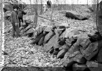
Native walls occur in various shapes, sizes and configurations.
Perhaps the most enigmatic style of
Native stonework, walls are found across the breadth of
North America. The various styles into which
these walls can be categorized include:
Note: unless a link is
underlined, it does not yet exist.
Early Accounts of Native Walls -
>>›››More›››
Links to Native Wall resources -
>>›››More›››

Stone fish weirs:
http://www.victorianvilla.com/sims-mitchell/local/native/vis/
http://www.lutins.org/thesis.html#2
http://www.lutins.org/basnj.html
Documentation of Native stone walls
As reported in late 2002 in the NY Times,
high-resolution sonar surveys of the Hudson river revealed ancient stone
walls: "The surveys have also turned up more mysterious structures,
including a series of submerged walls more than 900 feet long that
scientists say are clearly of human construction. They say the walls are
probably 3,000 years old because that was the last time the river's
water levels were low enough to have allowed construction on dry land."
source:
 Note this is a
conservative age estimate, at least one of the researchers
believes a 7,000-year-old age is more likely. Note this is a
conservative age estimate, at least one of the researchers
believes a 7,000-year-old age is more likely.
Scattered accounts of Native stone walls (a.k.a.
"fences") occur in early records, several of which are reproduced below:
-
Carl Bridenbaugh, editor, The Letters of John
Pynchon; Vol. 1, 1984; John Pynchon (founder of Springfield,
Massachusetts), in a letter to John Winthrop Jr. (then at New Haven,
Connecticut), dated Nov. 30, 1654:
"Sir I heare a report of a stonewall and strong fort
in it, made all of Stone, which is newly discovered at or neere
Pequot, I should be glad to know the truth of it fro your selfe,
here being many strange reports about it."
-
Queen's "Fort" (a.k.a. Quaipan's Fort) in Exeter,
RI is a massive stone construction of Native American origin, listed
on the National Register of Historic
Places since 1980. The contention that it was a fort makes no
sense, it is a religious complex.
-
Henry Baker, History of Montville, Connecticut,
1896; p.31:
"Owaneco . . . . afterwards gave them each [two Englishmen who had
rescued him from drowning] one hundred acres of land, which
transaction was afterwards confirmed by the General Court, and
ordered to be surveyed and laid out 'about a mile or two west
northerly of the ancient Indian fence, provided Oweneco hath
good right to said land, and is not prejudicial to any former
grant.'"
-
Stonington,CT Deeds 1664-1714. Book 2; Part
Three; 2:79: " . . .And from thence wee run North North East
Northerly twoo hundred and eightie eight rod where wee marked A
small wallnutt tree, and layed an heape of stones aboute it, and
marked seven notches on it A Litle within the Indian fence at
quahquetoye, And from Thomas Parke his Corner tree A white oack at
the Southeast corner of his four score Akres of Land formerly marked
on four sides and on heape of Stones layed . . . . The Above written
Act of surveighors was entered Januarie the 4th, 1680"
-
Ancestors and Descendants of Jonathan Abell, p.
11: [Rehoboth, MA] The 26th of the 12th mo., 1651, it was agreed
that Robert Abell and Richard Bullock should burn the commons round
about, from the Indian fence, all on the neck, and so far
about the fresh meadows as may be convenient; and they are to have
20s, for their pains, and to begin the 15th of March next, and to be
paid out of the first rate.
-
Jeremy Belknap, The History of New Hampshire,
Vol. III, 1792; p. 67:
“At Sanborntown there is the appearance of a fortrefs confifting of
five diftinct walls, one within the other, and at Hinfdale
there is fomething of the fame kind; but they are vaftly inferior,
both in defign and execution to the militiary works found in the
country of the Senekas and in the neighbourhood of the Ohio.”
-
The Smithsonian documented one of the massive Native
wall complexes in New Hampshire mentioned by Belknap:
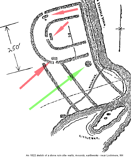
E. G. Squier, Antiquities of the State of New
York, Smithsonian Contributions to Knowledge, Vol. II, 1851; p.
145-6: “There are . . . some remains in the State of New Hampshire,
which, whatever their origin, are entitled to notice. The subjoined
plan of one of these is from a sketch made in 1822 by Jacob B.
Moore, Esq., late Librarian of the Historical Society of New York,
who has also furnished the accompanying description.
‘According to your
request, I send the inclosed sketch and memoranda of an ancient
fortification, supposed to have been the work of the Penacook
Indians, a once powerful tribe, whose chief seat was in the
neighborhood of Concord, New Hampshire. . . . Under the name of
Penacooks, were probably included all the Indians inhabiting the
valley of the Merrimack, from the great falls at the Amoskeag to the
Winnepiseogee Lake, and the great carrying-place on the Pemiqewasset.
That they were one and the same tribe, is rendered probable from the
exact similarity of relics, which have been found at different
places, and from the general resemblance of the remains of ancient
fortifications, which have been traced near the lower falls of the
Winnepiseogee, in Franklin and Sanbornton, and on the table-land
known as the Sugar-Ball Plain in Concord. . . . The accompanying
sketch was taken in pencil, on a visit to the spot, in company with
the Hon. James Clark and several friends in the month of September,
1822. The remains are on the west side of the Winnepiseogee, near
the head of Little Bay, in Sanbornton, New Hampshire. The traces of
the walls were at that time easily discerned, although most of the
stones had been removed to the mill-dam near at hand, on the river.
On approaching the site, we called upon a gentleman (James Gibson)
who had lived for many years near the spot, and of whom we learnt
the following particulars: He had lived in Sanbornton fifty-two
years, and had known the fort some time previous to settling in the
place. When he came to the town to reside, the walls were two or
three feet high, though in some places they had fallen down, and
the whole had evidently much diminished in height, since the first
erection. They were about three feet in thickness, constructed of
stones outwardly, and filled in with clay, shells, gravel, etc., and
such as men in a savage state would be supposed to use for such a
purpose. They were placed together with much order and regularity,
and when of their primitive height, the walls must have been very
strong--at least, sufficiently strong for all the purposes of
defence against an enemy to whom the use of firearms was unknown. .
. . When the first settlers discovered the fort, there were oak
trees of large size standing within the walls. Within the inclosure,
and in the mound and vicinity, were found innumerable Indian
ornaments, such as crystals cut into rude shapes of diamonds,
squares, pyramids, etc., with ornamental pipes of stone and
clay--coarse pottery ornamented with various figures--arrowheads,
hatchets of stone, and other common implements of peace and war. The
small [adjacent] island in the bay appears to have been a
burial-place, from the great quantity of bones and other remains
disclosed by the plough, when settlements were commenced by the
whites. Before the island was cultivated, there were several
large excavations resembling cellars or wells discovered, for
what purpose constructed or used, can of course be only conjectured.
. . . After writing thus far, I addressed a note to the Hon. James
Clark, of Franklin, New Hampshire, with inquiries as to the present
state of these ruins. Mr. Clark was kind enough at once to make a
special visit to the site of the ruins, in company with Mr.
Bradford, son of one of the settlers. The following is an extract
from his reply:
The remains of the walls are in part plainly to be traced; but the
ground since our former examination has been several years ploughed
and cultivated, so as to now give a very indistinct view of what
they were in our previous visit, when the foundation of the whole
could be distinctly traced. No mounds or passage-ways can now be
traced. . . . The stones used in these walls were obtained on the
ground, and were of such size as one man could lift; they were laid
as well as our good walls for fences in the north, and very regular;
they were about three feet in thickness and breast high when first
discovered. The stones have been used to fill in the dam now
adjoining. There were no embankments in the interior. The distance
between the outer and inner wall was about sixty feet; the distance
from the north to the south wall was about 250 feet, and from the
west wall to the river about 220 feet. There were two other walls
extending south to Little Bay. . . . The remains of a fortification,
apparently of similar construction to that above described, were
some years since to be seen on the bluffs east of the Merrimack
River, in Concord, on what was formerly known as Sugar-Ball Plain.
The walls could readily be traced for some distance, though crumbled
nearly to the ground, and overgrown with large trees.’ ”
The sketch referenced above can be viewed below. The
green arrow indicates a cairn, while the three red arrows point to the
blocking mounds opposite the entrances, a common theme in Mississippian
architecture, although usually constructed of earth. The horseshoe
design is a common Native religious architectural practice as well. It
should be noted that some of the walls (both in the horseshoe and the
portion south of it) are parallel, common features in Native wall
complexes.
Stone walls have also been found in the context of
numerous rockshelter excavations:
Bulletin of the Connecticut Archaeological Society, Number 32, 1963,
Rock Shelter Occupations by Connecticut Indians, C.C. Coffin, p. 7-11
[Claude Coffin was unquestionably the single individual in Connecticut
(if not all New England) with the greatest experience and knowledge in
locating and excavating Native sites of all sorts. During a long career
of excavation (which included the presidency of the Connecticut
Archaeological Society) spanning much of the Twentieth Century, Coffin
gained practical knowledge which has never been equaled.] Coffin lists
rock shelters he excavated in 17 Connecticut towns. Listed below are
excerpts from his report which record stone constructions found at the
rock shelters he excavated.
-
Double Beach (in Milford) - "A small stone wall was built on
the north end of the shelter."
-
East Haven - "I also found a stone fort at Mansfield Grove,
East Haven in April, 1928. This fort was located on a high point of
rocks. The walls of the fort were made of large rocks with an
opening to the south. The wall was about three and one half feet
high, and five feet square."
-
North Madison - "This was a very large shelter . . . . It reminded
me of a western cliff-dweller ruin. The entire floor was laid out in
sections by stone walls from two to three feet high."
-
Shelton - "Knells Rock Cave . . . . is six feet high and five feet
wide with a three foot high stone wall built across the
entrance."
-
Huntington - "Lookout Cave was located on June 7, 1931. . . . There
was a small entrance at the north end but it had been closed up by a
three foot high stone wall."
-
Monroe - "A shelter in Monroe was found October 13, 1935. . . . It
was twenty-five feet long, twelve feet wide and fifteen feet high at
the entrance. Outside the remains of the stone wall covering
the entrance were some fire pits."
Fairfield - "A shelter in Fairfield was located on July 6, 1940. . .
. It was enclosed on three sides by a stone wall three feet
wide by seven feet long by one and a half feet high."
-
Branford - "A rock shelter in the Stony Creek section of Branford
was visited on July 24, 1949. . . . The length of the entrance was
eighteen feet. The height of the entrance was four feet. The floor
width was eleven and one half feet to the back wall. A stone wall
extended around the entrance. The wall was twenty inches high but
part of it had fallen down.
Links to Native wall resources:
In the mid-1950's, Philip Smith of the
Peabody Museum at Harvard conducted field work to address the
subject of Native walls in the Southeast, producing an important
review article which examines this subject in the region
stretching from Georgia to Indiana:
Aboriginal Stone Constructions in the Southern Piedmont
(3.9 MB .pdf).
Fort Mountain State Park - "The Wall at Fort
Mountain is a simple rock wall, running for 855 feet, and
ranging from 2 feet to 6 feet in height at different points. Its
not known exactly who built the wall, or why, but the
construction date is estimated to be somewhere between 500 B. C.
and 1500 A.D. Similar walls have been found in Bartow, Catoosa,
Dade, Dekalb, Habersham, and Whitfield Counties in Georgia; at
Lookout Mountain in Tennessee; and at deSoto Falls in Alabama."
Quassakonkanuck - Rhode Island place name
meaning: Stone fence boundary mark; place at the stone wall
Northeastern Stone wall/boulder complexes
California's East Bay Walls
California walls photographs, including an apparent serpent
effigy wall
Berkeley, California walls: "Some are massive, over six feet
tall and run for miles."
Who built the East Bay [California] walls?
Illinois "stoneforts" with 2000-year-old walls up to 6 feet high
11 Illinois stoneforts listed, including Millstone Bluff, listed
on the National Register
Map of stone walls and mounds at Fourteen Mile Creek, Indiana
Fayette County, West Virginia - ancient stone wall nearly 10
miles long
Fayette County, West Virginia - hilltop wall enclosure of over
300 acres
Fort Mountain, Georgia - wall runs 855 feet east and west,
varying in height from 2 to 6 feet
and
Minnesota - Blue Mound stone wall, runs approximately 375 meters
east and west
Georgia - 6 mountaintop stone wall sites
Blue Jay, West Virginia stone fort along Beaver Creek
Plan of stone walls at above "fort"
California - Stone Alignments at Tomales Point
California- Stone fish traps

HOME
©
Copyright 2004-2005,
NativeStones.com.
All rights reserved. All original materials on this site are
protected by United States copyright law and may not be
reproduced, distributed, transmitted, displayed or published
without prior written permission. You may not alter or remove
any copyright notice from copies of the content. You may
download material from this site only for your personal,
noncommercial use. |